So lets start with Airmass types. Airmass thunderstorms develop from an instability of the atmosphere that is typically caused by daytime heating. Yes, that's right, the SUN can cause these storms to fire up. They are very common in the southeast during the summer when the sun heats up the lower layers of the atmosphere, creating a buoyant environment where warm moist air near the surface wants to rise and the relatively cooler air above it wants to sink. As soon as the rising warm, moist air reaches the Lifting Condensation Level, marked by the level where the air becomes completely saturated, the cloud starts to form. The illustration below shows how a mature thunderstorm looks after it has developed.
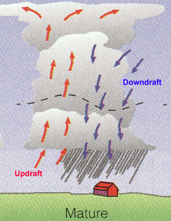
This is a simplified picture but even the more "complicated" picture is just an extension of this simple model. Below is a model of the three typical stages of these air mass storms. The first stage on the left comprises mainly all upward motion, developing the cloud but not precipitating. The middle stage is indicative of the picture above, with upward and downward motions in the cloud. This would be a mature thunderstorm. The final stage is when the downdraft is the only remaining motion and the storm is "emptying" the precipitation within it.

One other thing that has to be considered is that many storms are not just single cellular as in the cases above. Some systems involve multicells that consist of a combination of the 3 stages mentioned above.
Next, Supercells.
These are the major storms, that produce extreme hail and sometimes Tornadoes. They exist because of the same instability stated above, but also with the addition of something called wind shear, where wind at different levels of the atmosphere are at different speeds and move in different directions. The following image tries to show this feature

Supercells often form along a frontal boundary with considerable shear in the lower 300mb of the environment (1000 to 700mb layer) which is approximately 3km in height. Here are some photos of some of these storms in real life (these photos are not owned by me)


One of the other key features of these storms is the relative structure of precipitating regions and non-precipitating regions.

Out in front of the system, with the associated updraft, a downdraft will quickly form which is why the precipitation is focused towards the leading edge of the cloud base. Due to the shear mentioned before, any tornado that forms would likely occur "behind" the precipitation region, followed by an area of non-precipitating clouds called the flanking line, associated with another area of upward air motion.
These are some real basics on just two of the types of thunderstorm systems seen around the country (and world). I look forward to studying these more in graduate school and being apart of improving the forecasts of these storms.
Feel free to ask questions in the comment sections! I am by no means an expert in this topic but would welcome any questions you might have. I can always redirect you to someone or book who could help you more.
No comments:
Post a Comment