Contributors

Monday, February 28, 2011

Windy Weather

This morning's model runs have moved the low pressure system farther west and north than last night's runs which means a much less impactful storm for Western Washington. Ideally, for a strong wind storm to affect the Northwest, the track of the storm needs to be within the middle of Vancouver Island and the tip of the Olympic Peninsula. 


Granted this system will bring some very strong winds to the coast tomorrow and into Wednesday


Our weather pattern remains wet through the next week or so but temperatures remain cooler than normal.

Sunday, February 27, 2011

What? More snow? Well Maybe...

UPDATE: Latest UW model runs go back to "normal" with just heavy snow over the mountains and not the lowlands. Maybe some rain/snow mix showers in the morning, then just plain ole rain for tomorrow. Have a good night!

Ok folks here's the deal. There is a lot of uncertainty in this but this morning, the UW model runs came out with an "interesting picture" of some possible snowfall coming tomorrow morning. One of my professors at the university, Cliff Mass, wrote a blog about this earlier today and I would completely agree with him. This morning's run's painted a few inches of snow over a lot of Western Washington tomorrow morning.


This is 24hr snowfall totals ending 4pm Monday. Woah. There would be some Olympic "snow" shadowing again this time North and West of Seattle with heavier snowfall East of Seattle and South West. Now I don't want to send you into a panic because the previous model run showed this.


Just a few scattered snow showers South and East of Seattle. Maybe a little towards the Oregon coast too. This doesn't boast well for confidence in the event. Now UW runs the atmospheric models twice a day, morning and evening. So if this evenings model runs show a similar gruesome picture, tomorrow mornings commute could be hellish. Now one thing to be clear of, it will be plenty warm tomorrow so whatever falls tomorrow will likely melt. But that won't help with traffic and anything that sticks to roads could make driving to work a nightmare. I will update this post later tonight.

In the meantime, I will also say our "large" snow chances are dwindling this week. We have warmer temperatures, more Southwesterly flow aloft (bringing warmer air and not from Canada), and some systems moving in this week. However, these are not weak systems. Even the cold front moving through today will bring some outrageous snow totals to the mountains. The two pictures above showed nearly 3feet of snow over a 24hr period for many locations up in the Cascades. Travel over the passes this Monday and Tuesday could be very treacherous. In addition to that, a storm moving in Wednesday could bring in some very strong winds to the interior of Western Washington. Here is a surface map of the afore mentioned storm.


When you see those black lines are piled up together real close, that spells wind. Those lines are called isobars, lines of equal pressure in the atmosphere. Wind tends to flow from higher to lower pressure and the closer those lines are together, the stronger the winds. This could be a "significant" wind storm especially since the grounds are very saturated after the snow and the rain we've been dealing with. Here is a picture of the model forecasted winds for Wednesday (when the storm is expected to arrive)


Significant winds on the coast, out in the Pacific that black represents 45knot SUSTAINED winds. Yikes. In West. WA sustained winds forecasted in the 20-30knot range. You can roughly estimate gusts by multiplying the sustained winds by 1.5. In this case, gusts in the 35-45mph range. This may not seem significant but small microscale phenomenom can bring these gusts up even more and the soil isn't very strong at the moment because it is so saturated. This will need to be monitored for some damage certainly possible. Very strong winds along the Strait and into the San Juan islands. 

I hope this satisfies some of your hunger for weather info (It does for me :) ) and i'll be sure to update you on the snow situation later tonight. Or you can find me on Twitter: @huskyAaron and follow tweets about tonight. 


Thursday, February 24, 2011

Latest on Snow

So as I'm sure all of you could guess, the snow is winding down. A low pressure system off the coast is SLOWLY moving south towards California and it will bring its moisture down there too. It will also "release" a blast of cold air from Canada into Western Washington. This will bring very GUSTY winds to Bellingham and the San Juans with a Wind Advisory in effect for gusts to 55mph coming out of the Frasier River Valley. A hard freeze will dominate tonight with low temps tonight in the low 20s, teens, and some spots into the single digits. Tomorrow will remain chilly too with highs near freezing. Another hard freeze follows tomorrow night. It will remain dry tomorrow though with pretty clear and sunny skies

Saturday clouds start to roll in but it remains chilly and in the 30s. The next system moves in Saturday night bringing a chance over to warmer air. However, there will be enough cold air still around for the possibility of precipitation to start off as snow. Similar to what happened back in January, it will snow for 1-2" and then a quick change over to rain and warming. Temps will remain cool enough in the upper atmosphere though to keep snow levels relatively low which will bring heavy snows again to the mountains, something they desperately need for the ski resorts. We start to warm by Sunday with rain at times but still well below our average. Looks like next week offers off and on chance for more rain and cooler than normal temps, in the mid 40s.

No real show chance after the weekend. We have pretty much reached the point of no return part of the year for lowland snow. We start to warm and the chance for snow diminishes greatly by the beginning of March.

Saturday, February 19, 2011

More Snow Forecast

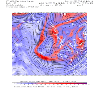
I know have been bringing hope as of late and then quickly taking it away...but what would be a Northwest Winter without disappointment? Well we have another snow situation setting up. This is looking much more like the classical pattern of snow here. The pattern is set up with a high amplitude ridge over the Eastern part of the pacific. Typically we want that ridge to really extend up to Alaska and beyond up towards the pole. We then need a shortwave system on the longwave pattern to move down from BC, come out over the water, and then move into SW Washington or NW Oregon. This does two things: one the system being so close will "pull" cold continental air from BC that will almost be hindered by a barrier. Well that barrier will cease to control the air with the system drawing that air out so the Northwest will be blanketed by some very cold air. Two: The closeness of the system spins the moisture up from the south and boom, snow. Here is a picture of that kind of situation. 
And guess what? That is the forecast picture for Wed/Thur. You don't need to know what exactly all the data is in this pictures, but just associate the Red with clouds and moisture. You can see the ridge, high amplitude over Alaska and above. And that low pressure system sitting right over us. Now this forecast can change over the next few days but this looks promising. Here is a picture of the surface. 
The surface map shows a surface low just offshore and do you see those black lines into BC that are all bunched up together? That is what the business calls an arctic front. Lots of cold air (the pink purple in Canada) is seperated from us mainly by the Rocky mountains and a low like this will draw that air out of the mountain gaps, pouring into the Northwest. Here is a map just a few hours later
The low has moved more south and that cooler air (even the light blue, turquoise, is very VERY cold) has begun really pouring over us. There may not be much moisture around at this point but this would spell a very cold streak. But lets not forget about the snow :)


This is a map for 24hr snowfall ending Wednesday afternoon...The snow certainly will be felt all around Western Washington. The models don't do a great job predicting snowfall amounts but what you can take from this is it will be affecting EVERYONE (maybe not some areas affected by a "snow" shadow, i'll talk about that in a future blog). Here is a later map. 


That is potentially 1-3 inches around the lowlands and higher amounts towards the foothills. This could get very interesting over the next few days when models start to really narrow down on what might happen. 

Thursday, February 17, 2011

latest Weather

Here is a short synopsis on the snow. The models previously had a system moving out of BC and moving right on top of us. Now? Thats not the cast. This picture illustrates where the low is not predicted to fall, well off the WA coast so no snow for the lowlands.
Friday and Saturday should be relatively pleasant and sunny days. The next system moves in Sunday night into Monday. Unfortunately for snow lovers, it appears it will take the same track as tonights system. Here is a picture of it.

You can see it is also WELL off the WA coast. A few days later,
that low moves well south and we get some action right on top of us. This isn't ideal for snow but it certainly needs to be watched over the next few days. In other weather news, we will remain cool for the next 7-10 days, well below our normal of 49 degrees. These low pressure systems tend to draw out cold air from BC, here is a picture of it.
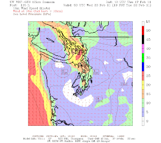
If you look close enough you can see the barbs pointing out of the north and northwest, a clear indication of Frasier River Outflow, where the cold air comes from. Suffice to say, even though no snow, we will be mighty chilly.

Wednesday, February 16, 2011

Latest on Snow

I don't have much to tell you in terms of snowfall over the next 24-48 hours. UW's modeling system which does high resolution runs (its much better in dealing with Washington terrain and microscale weather) was delayed this morning so only one run was available.

 This photo illustrates the pattern setting up tomorrow morning. The red illustrated upward motion in the atmosphere which is associated with clouds and precipitation. You can see the majority of WA has only spotty areas of red so any snow will be spotty at best. Snow levels will be around 500ft so some of the hilltops may see some snow. THIS IS NOT A GUARANTEE though because there may not be moisture around. Friday is looking much drier now with precip so it looks like that possibility is gone.

Saturday is looking pretty dry now, actually not a bad day to get outside with some partial clearing outside. The next system moves in late Sunday into Monday but models are in disagreement with where the system tracks. If it goes too far out over the Pacific, West of WA, then we won't get the moisture to give us snow while we are still cold. If it comes right on top of us, that is ideal for a snow maker. (The picture up above shows a Low pressure system and if that moves over us Thursday or Friday, that could ALSO give us more snow that we expect at the moment. Anything can happen).

Long story short:

Wednesday Night/Thursday Morning: CHANCE of snow showers, but very isolated. Mainly just 4am to 10am timeframe and will melt with highs into the 40s thursday.

Thursday night: 7pm-12am poss snow showers, less and less chance through the night.

Fri/Sat: Dry so no real chance of snow

Sun Late: Chance for snow increases again.

Will let you know if anything changes

Tuesday, February 15, 2011

Snow Chance

Well there is a lot to talk about today so lets just get started. First things first, after yesterday's round of Severe Thunderstorm Warnings and very gusty winds around much of Western Washington, and thousands of people losing power, we have calmed down considerably overnight. Some gusts in the Northwest Interior and over on the coast reached 60-70mph while the 520 floating bridge hit 46mph and Magnolia and the UW hit 44mph for top gusts. The chance for some strong, sudden gusts will continue through today. The National Weather Service issued a Special Weather Statement for the possibility of some strong thunderstorms moving across the area today. They could bring, heavy rain, hail, gusts to 45mph, and also cold-air funnel clouds (not something to worry about, but a great sight to see in the clouds. In the midwest, this is the beginning of a tornado).

A low pressure system just spinning off our coast is what's sending us this very unstable air and it will continue to park itself off the coast until Wednesday morning when it moves inland. An upper-level system will be moving over us by Wednesday as an upper-level ridge set up in the eastern Pacific. This pattern is a LA-NINA pattern! She has finally shown her face this winter. This brings all our systems from the North or Northwest instead of the Pacific ocean. These systems bring with them very cool air from the Gulf of Alaska. One of these systems will be moving through on Thursday morning and thats when we begin flirting with the chance of snow. Right now, it looks as if the snow level will be right around 500ft so some of the higher hilltops could see some snow and some heavier showers could bring the snow down to the sea level mark for the puget sound area. This will be a tricky situation because small changes could mean snow for everyone or no snow for anyone.

You'll start noticing this afternoon some cooler air moving in. Highs today will be in the mid 40s and by the weekend, we may not be getting out of the 30s for afternoon highs. Never doubt that Winter is over in January here in the Pacific Northwest.

It may be a little early but it looks like the overall pattern keeps us in this limbo with snow through the weekend.


I'll keep you updated on anything new coming out today. 

Thursday, February 3, 2011

2-3 Discussion

Our dry streak will cease to continue today as a warm front approaches the coast and begins to spread inland today. The heaviest rain will not move in until Saturday and Sunday but expect some light showers around for today as well as Friday. Afternoon temps today will hover right around 50 for most of Western Washington, so quite mild compared to the rest of the country. Seattle is warmer than Phoenix, Atlanta, Dallas, El Paso, and Tucson this morning.

This frontal system will stall out over us for Friday, keeping temps mild and a rain chance around. This will also bring some snow to the mountains, something we have not seen in quite a while up there. Freezing level will be around 3500ft tomorrow.

We will be mainly wet for the weekend with highs right around normal. It may not be very sunny but definitely normal this time of year.

Looks like the sun will return by the beginning of next week as another ridge of high pressure builds up over us. This means about normal for temperatures with afternoon sun. Something to look forward too!

Have a great day!