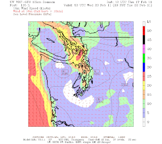
Friday and Saturday should be relatively pleasant and sunny days. The next system moves in Sunday night into Monday. Unfortunately for snow lovers, it appears it will take the same track as tonights system. Here is a picture of it.
Thursday, February 17, 2011
latest Weather
Here is a short synopsis on the snow. The models previously had a system moving out of BC and moving right on top of us. Now? Thats not the cast. This picture illustrates where the low is not predicted to fall, well off the WA coast so no snow for the lowlands.
You can see it is also WELL off the WA coast. A few days later, that low moves well south and we get some action right on top of us. This isn't ideal for snow but it certainly needs to be watched over the next few days. In other weather news, we will remain cool for the next 7-10 days, well below our normal of 49 degrees. These low pressure systems tend to draw out cold air from BC, here is a picture of it. If you look close enough you can see the barbs pointing out of the north and northwest, a clear indication of Frasier River Outflow, where the cold air comes from. Suffice to say, even though no snow, we will be mighty chilly.
Subscribe to:
Post Comments (Atom)


No comments:
Post a Comment