I don't have much to tell you in terms of snowfall over the next 24-48 hours. UW's modeling system which does high resolution runs (its much better in dealing with Washington terrain and microscale weather) was delayed this morning so only one run was available.
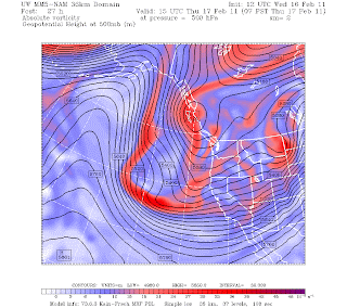
This photo illustrates the pattern setting up tomorrow morning. The red illustrated upward motion in the atmosphere which is associated with clouds and precipitation. You can see the majority of WA has only spotty areas of red so any snow will be spotty at best. Snow levels will be around 500ft so some of the hilltops may see some snow. THIS IS NOT A GUARANTEE though because there may not be moisture around. Friday is looking much drier now with precip so it looks like that possibility is gone.
Saturday is looking pretty dry now, actually not a bad day to get outside with some partial clearing outside. The next system moves in late Sunday into Monday but models are in disagreement with where the system tracks. If it goes too far out over the Pacific, West of WA, then we won't get the moisture to give us snow while we are still cold. If it comes right on top of us, that is ideal for a snow maker. (The picture up above shows a Low pressure system and if that moves over us Thursday or Friday, that could ALSO give us more snow that we expect at the moment. Anything can happen).
Long story short:
Wednesday Night/Thursday Morning: CHANCE of snow showers, but very isolated. Mainly just 4am to 10am timeframe and will melt with highs into the 40s thursday.
Thursday night: 7pm-12am poss snow showers, less and less chance through the night.
Fri/Sat: Dry so no real chance of snow
Sun Late: Chance for snow increases again.
Will let you know if anything changes

No comments:
Post a Comment